


Put together by Prof. David Millar ((20th May, 2024))
1.0 CONTEXT AND HISTORY OF THE PROJECT
Pwalugu project was firstly studied in 1993 at a prefeasibility level, along with two other schemes on the White Volta River (Kulpawn and Daboya) and one project on the Oti River (Juale). Pwalugu project was recommended as a priority project to foster economic development in Northern Ghana.
In 2013, the Volta River Authority (VRA) – the main power generation company in Ghana, solely owned by the Government of Ghana (GoG) – and TRACTEBEL signed a contract for the feasibility and detailed design studies of the Pwalugu Multipurpose Dam Project (PMDP). The Pre-Feasibility and Feasibility Studies were respectively completed in May 2014 and January 2016. The ESIA carried out by Mott McDonald highlighted important impacts related to the large dam reservoir.
In response to concerns about the environmental and social impact of the original dam height of 40m, the VRA requested TRACTEBEL to conduct complementary studies to assess different project options. This led to the reduction of the dam height to 35m.
In 2019, Government of Ghana decided to implement the project and mandated TRACTEBEL and SRC Consulting to carry out the Environmental and Social Impact Assessment Study (ESIA) and the Resettlement Action Plan (RAP) of the Pwalugu Multipurpose Dam Project (PMDP).
In its final design, the PMDP is intended to contribute to the economic development of Northern Ghana by several means:
- Developing the irrigation potential of the White Volta plains;
- Mitigating floods downstream of the dam;
- Generating power to be injected on the northern end of the national grid; Developing other economic activities on the reservoir, such as fishery.
1.1 Pwalugu Multipurpose Dam Project (PMDP) includes:
- A composite dam made of a rolled compacted concrete (RCC) dam in the central valley/riverbed, rockfill dam with clay core on the left Bank and an earth dam with clay core on the right bank. The maximum dam height is about 60 m asl, with a crest elevation set at 168m asl and 1.8 km long;
- A gated spillway equipped with 6 gates;
- Two bottom outlets with sills located at the dead storage level (137 m asl);
- Two power intakes (one per turbine) located at 137.10m asl;
- In order to be operated in case of maintenance of the two turbines, an independent outlet is set for the environmental flow located near the intakes of the two turbines at 137m asl.
- A Hydro-Power Plant located at the toe of the dam on the left bank with an installed capacity of 59.6 MW. The plant will comprise 2 Kaplan-type turbines with single capacity of 29,8, supplying an average 176 GWh/year of which 100 GWh will be delivered with 95% reliability every year;
- An irrigation weir located 50 km downstream of the main dam. The weir is composed by a concrete structure for the canal intake, a concrete primary weir to evacuate the normal operating flows and earthen gabion secondary weir to act as a spillway when floods occur. The weir is 1 km long with a crest elevation set at 133 m asl;
- A 161-kV power transmission line 15km long from the switch yard to the existing Tamale-Bolgatanga Transmission line.
- A 20,000ha irrigation development area located downstream of the weir (which is not part of the present ESIA);
- A Solar Plant with an installed capacity of 50 MW (which is not part of this ESIA).
A base camp is planned to house the project owner and contractor’s personnel during the construction period and to accommodate the operating personnel during the project’s operational life.
The PMDP will create two reservoirs:
- A main reservoir upstream of the main dam with a 2,6 billion m3 storage capacity and a 263 km² surface area, the FSL is set at 165m asl and the Maximum water level is set at 165.23 masl.
- A weir reservoir upstream of the weir with a maximum surface area of 81km2 (corresponding to the area flooded for a 1 in 1000 return period flood)
1.2 Dam alternatives study
In 2018, the VRA requested Tractebel to investigate five alternative scenarios (Alternatives 1 to 5) in addition to the one studied earlier throughout the Feasibility Study (Alternative 0).
In the previous studies, the dam design was driven by the maximisation of the energy generation and the development of 20,000 irrigated hectares in the downstream floodplain. The purpose of the alternatives study was to compare different alternative schemes with a dam sized for irrigation as the primary operational purpose.
The 5 alternatives were:
- Alternative 0: baseline scenario that corresponds to the Feasibility Study design with a main dam with an FSL =170m asl, a diversion weir and irrigation area of 20,000ha;
- The arrangement of Alternative 1 with a dam elevation set at FSL = 151m asl;
- Alternative 2 differs from Alternative 1 by the location of the axis of the main dam, which is set on the so called “upstream axis” identified at the pre-feasibility study stage with a FSL at 158.5 m, a diversion weir and an irrigation area of 20,000ha;
- Alternative 3 is made of one unique reservoir. This unique dam is located on the irrigation weir axis studied and investigated during the Feasibility Study (FSL= 140.5 m asl). The irrigated areas remain the same;
- Alternative 4: Located on the same site as Alternative 3, Alternative 4 dam crest is determined so that the reservoir can store enough water to irrigate 5,000 Ha by gravity (FSL= 137.5m asl). The dam is designed to allow future heightening of the dam permitting the extension of the irrigated area up to 20,000 Ha. dam axis that corresponds to the Feasibility Study irrigation weir axis
- The arrangement of Alternative 5 (current design) is similar that of the baseline scenario (Alternative 0), only the dam height differs. FSL = 165m asl;
With a dam crest located 5 meters below that of Alternative 0, Alternative 5 generates slightly less energy (-15%) but also limits the social and environmental impacts as its total reservoir area is reduced by more than 25%. Besides, the implementation of specific operating rules can prevent the river at Pwalugu from flooding 14 out of 15 years.
In conclusion, Alternative 5 (165m asl – the current design) was a well-balanced compromise as it manages to meet the triple objective of the dam: irrigation, energy generation and flood mitigation.
2.0 HUMAN ENVIRONMENT
The main characteristics of the human environment are as follows:
- The ZoI depends administratively on the Upper East (districts: Bawku West, Nabdam, Garu, Talensi, Binduri) and the North East Regions (districts: Bunkpurugu-Nyakpanduri, East Mamprusi, West Mamprusi).
- The population is mainly rural (79% and 70% for Upper East and North East regions respectively) and scattered in dispersed settlements.
- The Upper East Region has a population density of 147.3 Inhab/km² in 2020 (higher than the national density of 137 inhab. /km²). North East Region on the other hand has a population density of 64.89 inhab. /km².
- 49% of the population are women. The average household size is 6.3 The population consulted is young: the average age of the population is 23 years and more than 50% of the population is younger than 19 years old. 38.5% of households are Mole Dagbani, 20.1% Talensi, 13.5% Frafra and 13.3% Kusasi. 38% and 37% of the population is respectively Muslims and Christians.
2.1 Developing irrigation
Agriculture has a central socioeconomic position in Ghana. This sector accounts for 37.1% of the active population and 65.2% of the active rural population, 19.7% of Ghana’s current GDP, and about 30% of export earnings.
Although agriculture is a key part of the country’s economy, the structure of the sector is vulnerable and relies mostly on rainfed agriculture. Smallholder rain-fed farming using rudimentary technologies dominates the agricultural sector accounting for 80% of total agricultural production. Approximately 90% of smallholder farms are less than two hectares in size and produce a diversity of crops. Larger farms and plantations primarily cultivate cocoa, oil-palm, rubber and coconut, and to a lesser extent, cereals and pineapples
Farm mechanization is neither common, nor extensive with production remaining dominated by hoe and machete, albeit with some animal traction practiced here and there, especially in the North of the country. The agricultural sector is characterized moreover, by low use of inputs with small farmers having little access to inputs such as fertilizer, insecticides, high yielding varieties or irrigation-based cultivation.
Northern Ghana is characterized by less favourable conditions for agriculture than in the South. Not only does rainfall decreases the further north one travels in Ghana, but the rain is also concentrated in shorter periods with characteristic torrential rains. Because of the higher run-off induced by this rainfall pattern and of soils poor in organic matter, crop production can only take place in one, often erratic, season. Yet, despite these more difficult conditions, many more households in northern Ghana are dependent on agriculture than in southern Ghana. In total in Ghana, 44.1% of households own or operate a farm, while this figure is more than 70% in the five regions of the north[1].
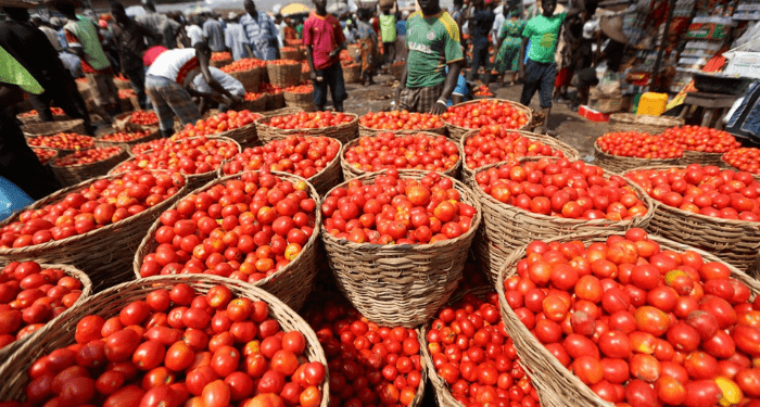
The total potential for irrigable land is estimated to be 1.9 million ha but only 11.7% (222,978 ha) is under full and/or partial control (in 2017)[2]. Of this total area, 13,009ha are distributed over 53 existing public irrigation schemes developed by the Ghana Irrigation Development Authority (GIDA)[3]. 210,000 ha have also been developed by private commercial and private small-scale irrigators. Under these conditions, irrigation development is view as: (i) a way to offer greater food security and bring northern Ghana out of poverty by ensuring yearlong agricultural production (ii) and as a useful strategy for adapting to climate change. One of the main goals of the PMDP is to develop the irrigation potential of the White Volta plains though a 20,000ha irrigation scheme. This irrigation scheme will be the largest in the country; it will boost agricultural production and set basis for agro-industries, including revival of Pwalugu tomato factory. It has the potential to produce 117,000 tons of rice and 49,000 tons of maize and reduce import by 16% and 32% respectively. Other crops will benefit from increased production: onion, tomatoes, sweet potato, sweet pepper and watermelon.
3.0 PROJECT DESCRIPTION AND ALTERNATIVES
3.1 Location
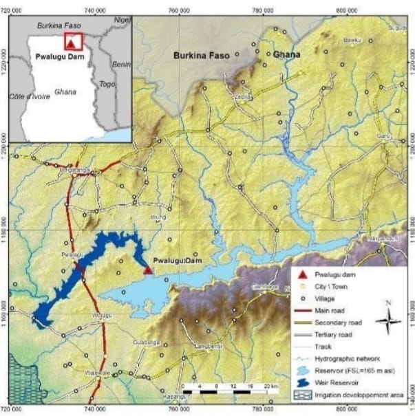
Pwalugu Dam site is located on the White Volta River, approximately 30 km Southwest of Bolgatanga, across the Upper East Region and the North-East Region.
PWALUGU MULTI-PURPOSE DAM LOCATION MAP
3.2 General description of the project
Overview
The Pwalugu Multipurpose Dam Project (PMDP) includes:
- A composite dam made of a rolled compacted concrete (RCC) dam in the central valley/riverbed, rockfill dam with clay core (asphalt core) on the left Bank and an earth dam with clay core (asphalt core) on the right bank. The maximum dam height is about 60 m asl, with a crest elevation set at 168m asl and 1.8 km long;
- A gated spillway equipped with 6 gates each of which is 10m×11m in size and has one radial gate, and one stoplog;
- Two bottom outlets with sills located at the dead storage level (137 m asl)
- Two power intakes (one per turbine) located at 137.10m asl, which both consist in an inlet structure and a 5.8 m diameter and 36.5m long steel penstock installed across the dam body
- In order to be operated in case of maintenance of the two turbines, an independent outlet was set for the environmental flow. The intake with a diameter of 1.2m asl, is located near the intakes of the two turbines at 137m asl.
- A Hydro-Power Plant located at the toe of the dam on the left bank with an installed capacity of 59.6 MW. The plant will comprise 2 Kaplan-type turbines with single capacity of 29,8, supplying an average 176 GWh/year of which 100 GWh will be delivered with 95% reliability every year;
- An irrigation weir located 50 km downstream of the main dam. The weir is composed by a concrete structure for the canal intake, a concrete primary weir to evacuate the normal operating flows and earthen gabion secondary weir to act as a spillway when floods occur. The weir is 1 km long with a crest elevation set at 133 m asl;
- A 161-kV power transmission line 15km long from the switch yard to the existing Tamale-Bolgatanga Transmission line.
- An access road
A base camp is planned to house the project owner and contractor’s personnel during the construction period and to accommodate the operating personnel during the project’s operational life.
The PMDP will create two reservoirs:
- A main reservoir upstream of the main dam with a 2,6 billion m3 storage capacity and a 263 km² surface area, the FSL is set at 165m asl and the Maximum water level is set at 165.23 masl.
- A weir reservoir upstream of the weir with a maximum surface area of 81km2.
The project will be put in combined operation with downstream Akosombo and Kpong upon completion of construction, and will perform regulation for the 2 downstream hydropower stations, and will cause additional irrigation area of 20,000ha and meet the requirements for domestic and drinking water for 30,000 persons in Walewale Town.
Accessibility
The project dam site can be accessed through the Talensi trunk road off the main
Tamale – Bolgatanga highway and then takes about one and half hours’ drive time from the Wulugu community to the site. Most part of the road to the site is untarred but fairly motorable.
The Project Weir site is accessible through the Talensi trunk road off the main Tamale –
Bolgatanga highway and then the unpaved road to Sariba for about 40 min. It then takes 20 min from Sariba to the weir site.
ACCESSIBILITY TO THE PROJECT SITE

GENERAL VIEWS OF MAIN DAM 3D MODEL
3.3 Access Road
3.3.1 Permanent access roads
The access road route is along the transmission lines on the basis of the following:
- it is the shortest way, criteria which has a direct economic advantage; • it forms a common work site with the construction of the transmission lines; • it can be used as an access to the transmission lines.
3.3.2 Temporary access roads
In addition to the permanent access roads that connect the site to the national road network, temporary roads will be constructed during the construction phase to provide access to the following sites:
- Quarries
- Fixed plants
Contractor’s Base Camp
- Storage area for excavated material
- Site Facilities
These temporary access roads will be constructed in a robust manner so that they will not be damaged by heavy traffic during the construction phase, but also due to the difficult weather conditions during the rainy season. Their design must also remain simple, as these roads must be created quickly in order to access the various locations on the site, but also because their lifespan is limited to the duration of the construction work.
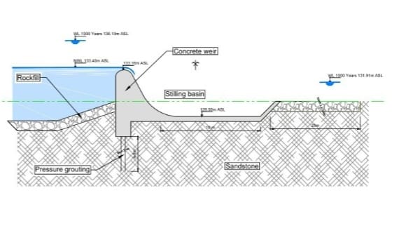
4.0 THE WEIR
The Pwalugu water diversion complex provides agricultural irrigation water for the 20,000ha of land on the left bank of the white Volta. The complex is located upstream of the irrigation area and 52 km downstream of the Pwalugu dam site.
IRRIGATION WEIR CONCRETE SECTION
5.0 CONSTRUCTION SCHEDULE
5.1 The total construction period is 44 months:
- 6 months of preparatory period,
- 5months of construction period for the main structures and
- 5 month of for completion of the work.
The number of workers needed for the construction is estimated to be 1,500.
6.0 EXPECTED OUTCOMES
6.1 Improvement of regional agricultural production
One of the main goals of the PMDP is to develop the irrigation potential of the White Volta plains through a 20,000ha irrigation scheme that will boost agricultural production and set basis for agro-industries. It has been estimated that it has the potential to produce 117,000 tons of rice and 49,000 tons of maize and reduce import by respectively 16% and 32%.
If the project is not developed, the irrigation of 25 000 ha will not be possible and the positive impact mentioned above will therefore not happen.
6.2 Flood mitigation
As mentioned throughout this document, Ghana is one of the countries in West Africa most affected by droughts and floods. Floods along the White Volta River are a recurrent phenomenon affecting thousands of people. The PMDP allow a protection against a 1 in 10 or 1 in 15 years return period flood event depending on the operating rules implemented. In the absence of the project the area will not be protected against floods with a return period of 10 or 15 years.
6.3 Improvement in Ghana’s power system
This project will improve Ghana’s power system with a coupled 59 MW hydro – 50 MW solar PV plants. If the project is not carried out, 276 GWh/year (176 GWh for hydropower and 100 GWh for the solar plant) will not be made available for Ghana’s power system.
6.4 Environment conservation
The “no project” situation is the most favourable scenario for ecological uses, as it maintains current natural and human uses.
- increase the fragmentation of the territory of the elephants and will create a barrier to the migration of this species on either side of the river.
- Elephants will lose about 5% of their territory. The loss of habitat generated a loss of food resources for these animals.
- The reservoir and the dam will constitute a barrier for the movement of elephants. The elephants will therefore try to bypass the reservoir, which could lead them to areas of villages on the side of the axis of the dam and the weir reservoir. It is unlikely that the animals will go all the way to the retaining tail to bypass the reservoir.
- Elephants will be greatly disturbed by this situation and may be even more aggressive. This situation will increase the already exiting HumanAnimal conflicts and could endanger the elephants.
- The PMDP will lead to the loss of land rights on a total area of 304.3 km² in the main reservoir area and 75 km² in the weir reservoir area.
- 814 households (4,228 people) distributed in 22 communities/settlements are located in the expropriation zone of the main reservoir and will have to be displaced;
- When considering the Q100 as the expropriation area a total of 11 households (62 people) distributed in 3 villages will have to be resettled in the weir reservoir area.
- The loss of public infrastructures: 19 Water access and sanitation infrastructures; 3 primary schools, 2 Junior High Schools, 1 CHPS compound, 6 mosques and 5 churches
- The PMDP will lead the loss of approximatively 8,000 to 10,000 ha of farm land in the main reservoir area
- The PMDP will lead to permanent loss of approximatively 1,000 ha of farm land in the weir reservoir area. Besides, the modification of hydraulic flow will affect nearly 2,000 ha of farmland in the weir reservoir area.
- The loss of 38 shrines, 5 archaeological sites and 18 graves
- An important risk of increasing the prevalence of waterborne diseases
7.0 Dam Alternatives Study
In response to concerns about the environmental and social impact of the original dam height, in 2018, the VRA requested Tractebel to investigate five alternative scenarios (Alternatives 1 to 5) in addition to the one studied earlier throughout the Feasibility Study (Alternative 0).
In the previous studies, the dam design was driven by the maximisation of the energy generation and the development of 20,000 irrigated hectares in the downstream floodplain. The purpose of the alternatives study was to compare different alternative schemes with a dam sized for irrigation as the primary operational purpose.
7.1 The 5 alternatives are described below:
- Alternative 0: baseline scenario that corresponds to the Feasibility Study design with a main dam with an FSL =170m asl, a diversion weir and irrigation area of 20,000ha;
- The arrangement of Alternative 1 is similar that of the baseline scenario, only the dam height differs. FSL = 151m asl;
- Alternative 2 differs from Alternative 1 by the location of the axis of the main dam, which is set on the so called “upstream axis” identified at the pre-feasibility study stage with a FSL at 158.5 m, a diversion weir and an irrigation area of 20,000ha;
- Alternative 3 is made of one unique reservoir. This unique dam is located on the irrigation weir axis studied and investigated during the Feasibility Study (FSL= 140.5 m asl). The irrigated areas remain the same;
- Alternative 4: Located on the same site as Alternative 3, Alternative 4 dam crest is determined so that the reservoir can store enough water to irrigate 5,000 Ha by gravity (FSL= 137.5m asl). The dam is designed to allow future heightening of the dam permitting the extension of the irrigated area up to 20,000 Ha. dam axis that corresponds to the Feasibility Study irrigation weir axis
- The arrangement of Alternative 5 is similar that of the baseline scenario (Alternative 0), only the dam height differs. FSL = 165m asl;
The Full Supply Levels of Alternatives 1 to 4 correspond to the lowest level that create active storages large enough to satisfy the irrigation and environmental water demands.
The change of the dam main objective from energy generation (Alternative 0) to irrigation (Alternatives 1 to 4) has a huge impact on the dam design as it results in a dam height divided up by around 2 as compared to the previous dam studied during the Feasibility Study. As the negative environmental and social impacts of the alternative dam schemes as well as their construction costs significantly decrease, the lowering of the dams also reduces their active storage capacity thus affecting the power generation and flood mitigation performances of the schemes.
With a dam crest located 5 meters below that of Alternative 0, Alternative 5 generates slightly less energy (-15%) but also limits the social and environmental impacts as its total reservoir area is reduced by more than 25%. Besides, the implementation of specific operating rules can prevent the river at Pwalugu from flooding 14 out of 15 years. In conclusion, Alternative 5 (165m asl) was a well-balanced compromise as it manages to meet the triple objective of the dam: irrigation, energy generation and flood mitigation.
| ADDITIONAL BENEFITS YOU SHOULD KNOW ABOUT
PWALUGU MULTI-PURPOSE DAM 1. The Pwalugu Multi-Purpose Dam, though sited at Kurugu in the North-East Region, its impact will be felt in North East Region, Upper East Region, Upper West Region, Savanna Region, Northern Region, Parts of Brong Ahafo and Oti Regions (7 Regions of Ghana). Hence direct use and potential use of this facility is for the entire half of Ghana. 2. This is a Two-In-One Dam: The Dam actual and 52 km downstream the Weir (another smaller dam). The land area of 20,000 ha is the developed irrigable area. The land between the Dam and the Weir also has potential for cultivation. 3. The other lands that will be visited by the run-off after use for official irrigation; “Jungle Water”; a terminology which is commonly used by irrigation farmers who coined the term “Jungle Farmers” for themselves, is a very critical by-product. The area that has the potential to use such waters is not calculated but the estimations is that it may, in total, double the irrigated land from 20,000 ha to additional 40,000 ha. It is this water that will inure largely to the benefits of other 7 Regions of Northern Ghana listed above. 4. The 1,500 employment opportunities in the Project Design are largely of Project Staff. The undocumented employment generation for especially the youth in agricultural (using “Jungle Water”), would easily get to 100,000 employees. People seeking to sell farm-labour or engage in fishing in the 7 Regions could easily access the watered areas by virtue of the geographical location of the irrigable land. 5. 3,600 tons of fish is estimated to be produced by the Dam Project. The year-round “Jungle Water” will easy yield additional 5,000 tons of fish. Direct engagement in Fish Farming could easily cascade the supply of Fish to 10,000 tons coming from the North. 6. For livestock development, especially large herds of cattle, with year-round water availability, which means year-round green-grass abutting the water bodies, this will easily double the population of cattle (from about 60,000 herds to 120,000 herds). If Pastures and Ranching are developed, livestock population could easily be quadrupled (240,000 herds). ADD THE FULANI HERDSMEN (also Ghanaian). 7. Domestic Water Use: A 30,000 population water supply system is foreseen for Walewale in this Project. However, others living very close to the water bodies would certainly be using the water for domestic purposes where there are no water-systems; especially of rural communities abutting the waters as is done with Bontanga, Vea, and Tono. 8. Staff settlements: With the improved road networks in the general Dam area and the development of settlements for Project Staff foreseen, it is certain that a Township will eventually develop introducing various commercial activities for income generation; especially for the women. 9. How about water (boat transport)? Low levels of Gupe especially in the dry season is reported to be the bane to water transport. Guaranteed level of water especially in the dry season would provide opportunity for development water transport (by communities). 10. The sprouting and growth of New Communities along the water bodies will result in various livelihood developments activities that will catapult food security for the various inhabitants/ migrants to very high levels. 11. The increase and enrich biodiversity, vegetational cover, growth of fauna and flora, wildlife enhancements, all critical for enhance our environment and, in so doing, mitigate against climate change, will be enhanced. 12. Development of a micro-climate that would recharge ground water aquifers and moisturise evapotranspiration emissions in the atmosphere are remote but real contributions of the PWALUGU MULTI-PURPOSE DAM PROJECT. By Prof. David Millar 26 / 06 / 2021 |
ADVOCACY BRIEF
WHAT WE ARE ADVOCATING (Providing an Alternative to the status quo)
We start by appreciating and applauding ALL GOVERMENTS SINCE INDEPENDENCE (since Dr. Kwame Nkrumah, first President of the Republic of Ghana) for sustaining the PMDP on the radar of Ghana’s Developmental Agenda. Every Actor in this endeavour plaid his/her part very well according to their scripts.
This is the current Project Organisation under the Vice President that is plagued with numerous challenges:
- The Pwalugu Development Committee, comprising the Office of the Vice President,
- Ministries of Finance,
- Energy,
- Agriculture,
- Attorney General, will provide overall guidance to the project.
- VRA will manage the project activities through a dedicated Project Secretariat.
HENCE OR OTHERWISE, THE FOLLOWING CHANGES ARE PROPOSED GOING FORWARD FROM (2025):
- Since the benefits of the Pwalugu Multi-Purpose Dam spill over into Seven (7) Regions (see above narrative of Additional Benefits) it should be designated a National Project, not only Project for the North (a Project to turn the North around).
- PMDP should be recognised as a Very Special Presidential Initiative Project (VSPI) – DIRECTLY UNDER THE PRESIDENT’S OFFICE
- PMDP be given the National Character we envisage and thus should have a conjoint responsibility of both the Government in Power and the Leading Opposition. Both the President and the Opposition Leader should jointly be liable for its failures and jointly applauded for the successes of the new PMDP.
- The President should be responsible for championing Execution and the Opposition Leader for championing the keeping it in check – Whistle-blowing. The Countervailing Powers of the Opposition should be very visible, proactive, and timely thus:
- A Quarterly Forensic Monitoring and Reporting by the Government to the Citizenry and Civil Society; and a Half-Yearly Citizens Accountability Conference led by the Opposition (with Civil Society) these should be officially scheduled and mounted.
TO BE ABLE TO DO THE ABOVE THE GOVERNMENT OF THE DAY SHOULD MAKE PUBLIC (Public Hearings):
- The Entire Project Budget of the Revisited PMDP.
- Make visible the sources of funding, and annual expenditure blocks.
- Project is a 44 months Design; work into it direct timelines for the Quarterly Reporting by Government and Half-yearly Conference by the Opposition.
- A very unambiguous Time Table with concrete deliverables.
As a Country, we should-hit-the-ground-running with PMDP. The 70 years that PMDP has spent on the drawing board is most regrettable but salvageable.
This will be a sure test-case of how Ghana can go beyond partisanship and proffer to the world a healthier and compromising democratic dispensation when we collective wear the True-Development-of-the-Poor-Lens.
BIBLIOGRAPHY
- This Write-up has borrowed extensively excerpts from the Environmental Impact Statement (EIS) Report that TACTEBEL and SRC CONSULTING submitted to Volta River Authority (May 31th, 2021).
- This is supplemented by my own Professional and Consultant knowledge on the subject matter based on works done elsewhere (also of 26th, June, 2021).
- Bits and pieces were enriched by Internet Documentation.
Put together by Prof. David Millar ((20th May, 2024))
Source: Apexnewsgh.com
Thanks for reading from Apexnewsgh as a news publishing website from Ghana. We encourage you to freely share this story via social media platform and follow us on; Facebook on APEXNEWSGH-Tv or Please contact Apexnewsgh.com on email apexnewsgh@gmail.com for your credible news publications. Contact: 0248250270/0256336062.