


Pwalugu Multi-Purpose Dam Advocacy Brief
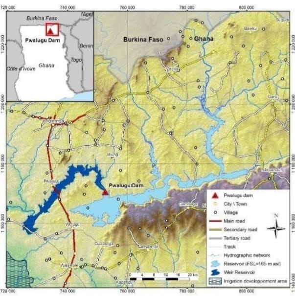
Put together by Prof. David Millar ((20th May, 2024)) 1.0 CONTEXT AND HISTORY OF THE PROJECT Pwalugu project was firstly studied in 1993 at a prefeasibility level, along with two other schemes on the White Volta River (Kulpawn and Daboya) and one project on the Oti River (Juale). Pwalugu project was recommended as a priority project to foster economic development in Northern Ghana. In 2013, the Volta River Authority (VRA) – the main power generation company in Ghana, solely owned by the Government of Ghana (GoG) – and TRACTEBEL signed a contract for the feasibility and detailed design studies of the Pwalugu Multipurpose Dam Project (PMDP). The Pre-Feasibility and Feasibility Studies were respectively completed in May 2014 and January 2016. The ESIA carried out by Mott McDonald highlighted important impacts related to the large dam reservoir. In response to concerns about the environmental and social impact of the original dam height of 40m, the VRA requested TRACTEBEL to conduct complementary studies to assess different project options. This led to the reduction of the dam height to 35m. In 2019, Government of Ghana decided to implement the project and mandated TRACTEBEL and SRC Consulting to carry out the Environmental and Social Impact Assessment Study (ESIA) and the Resettlement Action Plan (RAP) of the Pwalugu Multipurpose Dam Project (PMDP). In its final design, the PMDP is intended to contribute to the economic development of Northern Ghana by several means: Developing the irrigation potential of the White Volta plains; Mitigating floods downstream of the dam; Generating power to be injected on the northern end of the national grid; Developing other economic activities on the reservoir, such as fishery. 1.1 Pwalugu Multipurpose Dam Project (PMDP) includes: A composite dam made of a rolled compacted concrete (RCC) dam in the central valley/riverbed, rockfill dam with clay core on the left Bank and an earth dam with clay core on the right bank. The maximum dam height is about 60 m asl, with a crest elevation set at 168m asl and 1.8 km long; A gated spillway equipped with 6 gates; Two bottom outlets with sills located at the dead storage level (137 m asl); Two power intakes (one per turbine) located at 137.10m asl; In order to be operated in case of maintenance of the two turbines, an independent outlet is set for the environmental flow located near the intakes of the two turbines at 137m asl. A Hydro-Power Plant located at the toe of the dam on the left bank with an installed capacity of 59.6 MW. The plant will comprise 2 Kaplan-type turbines with single capacity of 29,8, supplying an average 176 GWh/year of which 100 GWh will be delivered with 95% reliability every year; An irrigation weir located 50 km downstream of the main dam. The weir is composed by a concrete structure for the canal intake, a concrete primary weir to evacuate the normal operating flows and earthen gabion secondary weir to act as a spillway when floods occur. The weir is 1 km long with a crest elevation set at 133 m asl; A 161-kV power transmission line 15km long from the switch yard to the existing Tamale-Bolgatanga Transmission line. A 20,000ha irrigation development area located downstream of the weir (which is not part of the present ESIA); A Solar Plant with an installed capacity of 50 MW (which is not part of this ESIA). A base camp is planned to house the project owner and contractor’s personnel during the construction period and to accommodate the operating personnel during the project’s operational life. The PMDP will create two reservoirs: A main reservoir upstream of the main dam with a 2,6 billion m3 storage capacity and a 263 km² surface area, the FSL is set at 165m asl and the Maximum water level is set at 165.23 masl. A weir reservoir upstream of the weir with a maximum surface area of 81km2 (corresponding to the area flooded for a 1 in 1000 return period flood) 1.2 Dam alternatives study In 2018, the VRA requested Tractebel to investigate five alternative scenarios (Alternatives 1 to 5) in addition to the one studied earlier throughout the Feasibility Study (Alternative 0). In the previous studies, the dam design was driven by the maximisation of the energy generation and the development of 20,000 irrigated hectares in the downstream floodplain. The purpose of the alternatives study was to compare different alternative schemes with a dam sized for irrigation as the primary operational purpose. The 5 alternatives were: Alternative 0: baseline scenario that corresponds to the Feasibility Study design with a main dam with an FSL =170m asl, a diversion weir and irrigation area of 20,000ha; The arrangement of Alternative 1 with a dam elevation set at FSL = 151m asl; Alternative 2 differs from Alternative 1 by the location of the axis of the main dam, which is set on the so called “upstream axis” identified at the pre-feasibility study stage with a FSL at 158.5 m, a diversion weir and an irrigation area of 20,000ha; Alternative 3 is made of one unique reservoir. This unique dam is located on the irrigation weir axis studied and investigated during the Feasibility Study (FSL= 140.5 m asl). The irrigated areas remain the same; Alternative 4: Located on the same site as Alternative 3, Alternative 4 dam crest is determined so that the reservoir can store enough water to irrigate 5,000 Ha by gravity (FSL= 137.5m asl). The dam is designed to allow future heightening of the dam permitting the extension of the irrigated area up to 20,000 Ha. dam axis that corresponds to the Feasibility Study irrigation weir axis The arrangement of Alternative 5 (current design) is similar that of the baseline scenario (Alternative 0), only the dam height differs. FSL = 165m asl; With a dam crest located 5 meters below that of Alternative 0, Alternative 5 generates slightly less energy (-15%) but also limits the social and environmental impacts as its total reservoir area is reduced
Pwalugu Multi-Purpose Dam: Stakeholders Finalize Land Issues
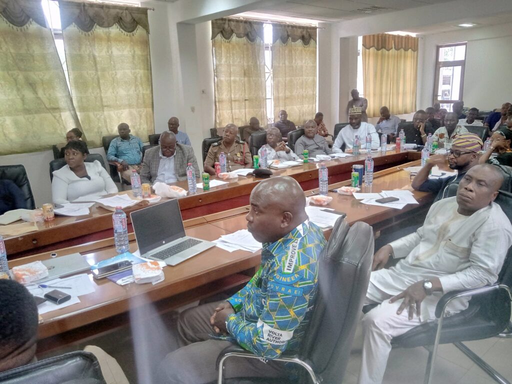
The Lands Commission and the Site Advisory Committee working on the Pwalugu Multi-purpose Dam Project have finalized land acquisition issues with stakeholders in the Upper East and North East Regions for the project to commence. Mr. Emmanuel Nartey, the Settlement Manager of the Volta River Authority (VRA), who updated the stakeholders on the progress of work, said community engagements and land mapping were completed with resettlement processes ongoing. He said a total of 814 households comprising 4,228 people spread across 22 communities in the main reservoir, 11 households made of 52 people across three communities in the Weir area who were physically affected would be resettled. He said 335 households with human population of 2,618 who were economically displaced would be provided with agriculture development support, marketing schemes and technology improvement facilities to sustain their livelihoods. For social cohesion, the Resettlement Manager said 10 community centers and five Chief Palaces would be constructed at convenient locations including five churches, six mosques and football parks would also be provided in all the four resettlement towns which would further be connected to the national grid. Mr. Nartey said the communities would also benefit from CHPS compounds with staff accommodation, while two health facilities at Wulugu and Samni would be upgraded and equipped to supplement health care delivery. Four Kindergarten, Primary and three Junior High Schools would be built, boreholes and water points would also be provided with toilet facilities in each resettlement, and 80kilometre link feeder roads would be constructed within the communities. The Upper East Regional Minister, Hon Stephen Yakubu, in his address, reiterated government’s commitment to the construction of the Multi-purpose Dam. He said it took a “Visionary leader in the person of President Nana Addo Dankwa Akufo-Addo to demonstrate the commitment to the people of the North that this laudable vision could be executed to the benefit of all Ghanaians. “Apart from serving as a reservoir or receptacle to harvest water from the upland which has been the main source of our perennial floods from the Bagre Dam, it would also provide 25,000 hectares of irrigable land and Hydro- Solar hybrid system of 60 Megawatts Hydro Power and 50 Megawatts Solar Power,” he said. Hon Yakubu said the project was a game-changer that would check the migration of the youth from the North to the south for greener pastures. Mr. Daniel Onny, the Pwalugu Multi-Purpose Dam Project Manager, said the World Bank had given the assurance that it would soon release funds for the project to start. UER-RCC